Hills and mountains, Jamalpur
Lauchapra hillsলাউচাপড়া পাহাড়
- Time needed
- Two to three hours.
- best months
- Nov–Feb
Jamalpur's corner of the Garo Hills at Bakshiganj: forested ridges on the Meghalaya border with a recreation centre of 1994, watchtowers that look into India, a small lake and Garo and Koch villages on the slopes.
Plan your visit
- Best time
- November to February; mist on the hills in the early morning.
At a glance
- Opened
- 1994, Jamalpur Zila Parishad
- Area
- About 11 acres of a much larger forested ridge
- From Bakshiganj
- About 15 km; 55 km from Jamalpur town
About
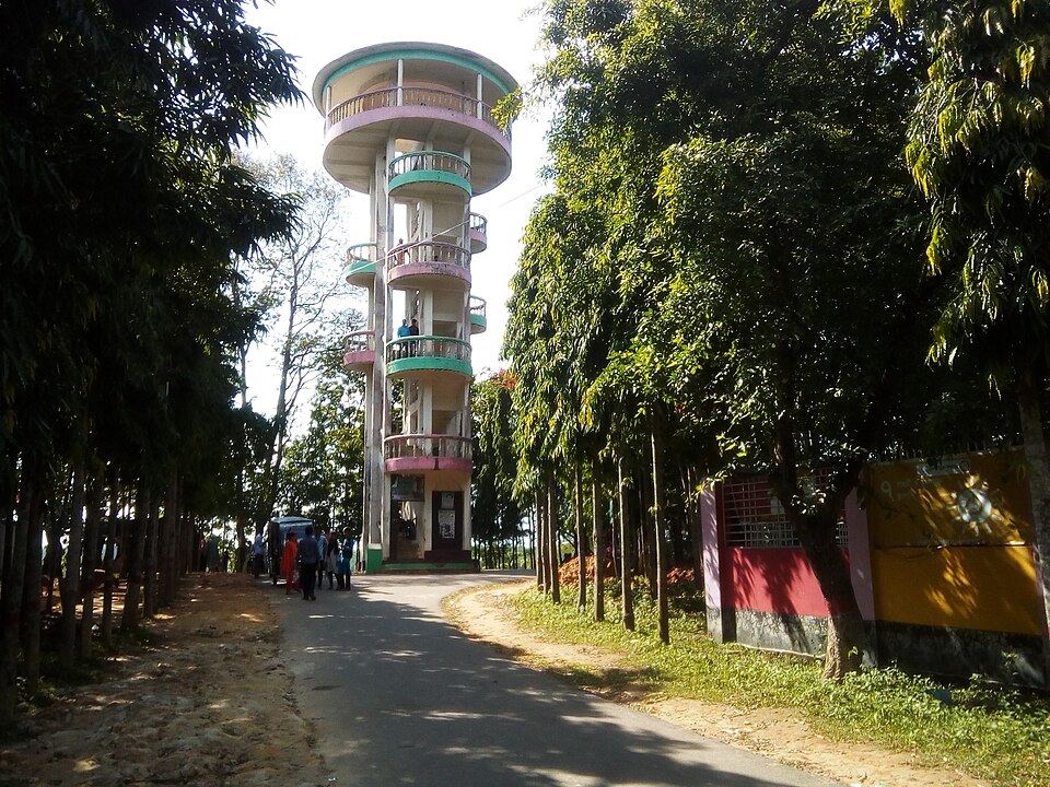
Lauchapra is where Jamalpur runs out of plain. About 15 km from Bakshiganj town and 55 from Jamalpur, the land lifts into the first red ridges of the Garo Hills, covered in sal and gajari, with Meghalaya's higher hills a few kilometres behind. The Zila Parishad opened a recreation centre here in 1994 on about eleven acres: two viewing towers on hilltops and a taller one reached by a zigzag stair, a picnic ground, a lake with two bridges, rest houses and a children's corner. From the towers you look across the forest into India, which is why people come.
The villages along the slopes, Lauchapra, Palashtala, Dighlakona, are Garo, Hajong and Koch, and women from them sell woven cloth and crafts at the foot of the hill on busy days. The centre has had thin years, with electricity, water and the access road all unreliable, so treat it as a day out in the hills rather than a resort: come for the walk up, the view and the quiet.
It lies a short way from the Kamalpur border, and across the hills from Rajar Pahar in Sherpur.
Getting there: From Jamalpur town a bus or CNG to Bakshiganj, then a CNG or motorcycle for the last 15 km; or from Sherpur through Sreebardi, about 25 km of better road.
Things to do
- Climb the zigzag stair to the tall tower for the view into Meghalaya.
- Walk the ridge paths through the sal forest.
- Buy woven cloth from the Garo women at the foot of the hill.
Good to know
- Bring water and food; there is little to buy and the rest houses are not reliable for a night.
- Mobile signal is weak; tell someone your plan and be down before dark.
- Many drivers go round through Sreebardi in Sherpur; ask about the state of the direct Kamalpur road before you set off.